Chile quake hazards remain high
- Published

Scientists say the potential remains for further big earthquakes in North Chile, along the stretch of coast hit by a Magnitude 8.2 tremor in April.
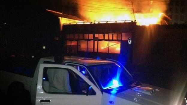
Six people lost their lives and 13,000 homes were destroyed or damaged in the event, which also triggered a tsunami.
Two teams have now reviewed all the seismic and geodetic data from the quake that struck near Iquique City.
They tell Nature magazine that the levels of strain in the rocks of the region are still hazardously high.
And the researchers say communities should prepare for the possibility of future events being much more energetic even than the 1 April rupture.
The teams point to areas just to the south or perhaps to the north of the Iquique quake being most at risk.
"I think the risk is greatest to the south because it seems the southern section might be more locked than the northern section - and by locked, I mean it has accumulated more potential energy over the last 150 years than has the northern section," Gavin Hayes from the United States Geological Survey told BBC News.
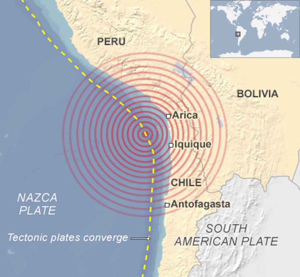
Chile runs along the boundary between the Nazca and South American tectonic plates.
These are vast slabs of the Earth's surface that grind past each other at a rate of up to 80mm per year.
The Nazca plate, which makes up the Pacific Ocean floor in this region, is being pulled down (subducted) and under the South American coast.
It is a process that has helped to build the Andes and made Chile one of the most seismically active locations on the globe.
The 1 April event this year occurred in what scientists refer to as a "seismic gap" - a segment of the plate boundary that has been relatively quiet for a significant period of time.
The last major event close to Iquique was the magnitude 8.8 tremor of 1877, which claimed more than 2,000 lives.
Dr Hayes' group - and a team led by Bernd Schurr from the German Research Centre for Geosciences, Potsdam, Germany - have separately reviewed all the monitoring data from April and combined it with their models for how the local subduction system works.
Both teams say that the 2014 quake, together with its sequence of foreshocks and aftershocks, was insufficient in scale to remove all the strain that had built up in the rocks since 1877.
"Only one-third of the gap was broken and the remaining locked segments now pose a significant, increased seismic hazard with the potential to host an earthquake with a magnitude [greater than] 8.5," write Dr Schurr and colleagues in Nature. In terms of the energy released, an 8.5 event is almost three times as big as an 8.2.
CCTV from inside a supermarket when the tremors struck has been released
Dr Hayes said Chilean and global seismologists now had the difficult task of communicating the uncertain but possibly elevated hazards, without appearing alarmist.
"People need to remain vigilant - is the message I've been trying to get across," the USGS researcher stressed.
"They were pretty well prepared before April 2014 for a big event, and they just need to maintain that sense of preparedness.
"The gap could be filled by one event of Magnitude 8.5 or bigger, or by a series of smaller events."
That the Hayes and Schurr groups have been able to complete their assessments is a consequence of the recent deployment of modern geodetic and seismic instrumentation in the region.
Nonetheless, argues Prof Roland Burgmann from the University of California at Berkeley, US, these monitoring networks could still be extended.
"Substantial efforts have been made to improve the monitoring on land, but the earthquakes in places like Chile or Japan really occur under the ocean, quite some distance away from the geophysical networks," he told the BBC's Science In Action programme.
"We'd really like to get closer to the earthquakes and sources of deformation by putting stations on the seafloor.
"That is technologically challenging but it is something which is being done now, especially in Japan. Since the 2011 [Tohoku] earthquake, they have really enhanced their activities offshore to get closer to these processes and thereby better understand what is happening out there."


Jonathan.Amos-INTERNET@bbc.co.uk and follow me on Twitter: @BBCAmos
- Published2 April 2014
- Published2 April 2014
