Your pavement squiggle markings decoded
- Published
.jpg)
They are the fleeting multi-coloured maps that chart the lay of the land beneath our feet. They tell those who dig up our roads where exactly the pipes and cables run, and, just as importantly, at what depth. Here we decode readers' road squiggle finds.
The product of convention rather than law, the different colours used in pavement markings refer to a particular utility.
Red, for example, is the colour of electricity. Blue denotes water while yellow means gas, green means CCTV or cable firm networks and white, telecommunications (or general messages to contractors carrying out works). The numbers between the lines are used spell out the distance from the kerb of a particular pipe or a cable or - if a D is used - its depth.
And as this network of pipes and cables becomes ever more congested, so specialist "locating companies" are increasingly the ones mapping out this subterranean world. John Robinson is managing director at Subscan Technology, one of these locating companies. Here he decodes images sent in by readers.
Road crossings
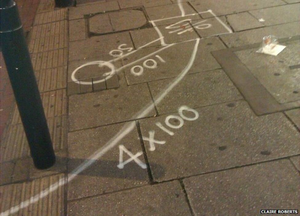
"This looks like it is for proposed works for installing a pedestrian crossing or similar," says Robinson. "The numbers relate to the size of PVC duct that will be laid in the ground to accommodate the cables."
In the example above, the markings mean there will be four 100mm ducts used.
Gas and water
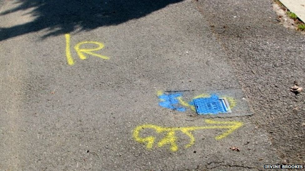
"This is a gas main that has been detected for position by ground-penetrating radar (GPR)," said Robinson.
"The line with R (for radar) next to it indicates the position of the main running parallel to the road.
"The line with GAS next to it shows the direction of an individual gas house connection pipe.
"The blue dot identifies a water stop valve that isolates an individual property."
Wired up

"This is a very busy footpath with numerous electric, traffic light and cable TV cables.
"Each colour denotes a different electric/IT provider.
"The dots indicate the position of each cable or duct. The writing 2 way is a term used to indicate that there are two cables or ways within a single cable duct."
Information technology

"I believe that this may be to do with multiple information technology ducting," says Robinson, who said the numbers suggest there are 11 ducts and that they are 1.5m deep at this position.
Traffic lights

"Again," says Robinson, "this is to do with traffic lights or pedestrian crossing.
"This is an inspection cover that contains the cabling systems (electric and IT) that control traffic lights.
"The red circles denote how many cable ducts leave the chamber and the blue dots indicate how many ducts are active and have cables in them.
"The number relates to the depth measurement from surface to top of duct in centimetres."
Water

"This is a water pipe that has been detected for position by two separate methods.
"The blue line with an R means that ground-penetrating radar (GPR) has been used.
"The white line with P means that passive electromagnetics have been used.
"By using two separate methods of detection this will increase the accuracy and confidence in the detection process," says Robinson.
Voltage

"This is an electric sub-station that switches high-voltage cables (11,000 volts or above) to a lower voltage that can supply small industrial and domestic properties.
"The high voltage enters on the right hand side of the apparatus and exits on the left at a lower voltage.
"The red cables (and paint) is the high voltage and the green is the low/medium voltage," says Robinson. "The numbers must relate to a schematic numbering plan of some sort to distribution identification."
Utilities

"Here we have a typical suburban footpath with electric (red) BT cables (white) water (blue) and cable TV (green)," says Robinson. "Each mark indicates the utility position. Numbers adjacent to the lines indicate depth to the top of the utility in centimetres."
Excavation
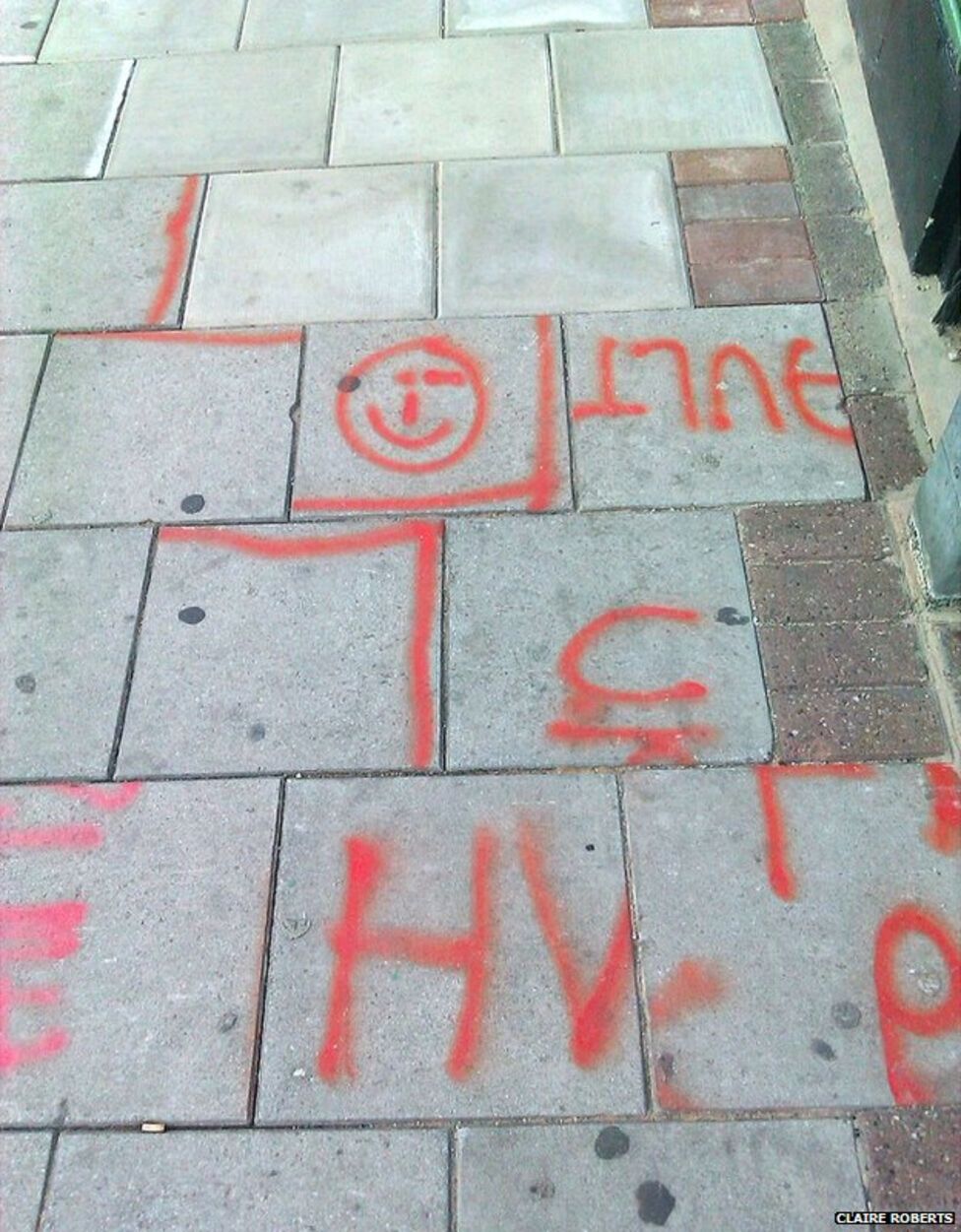
"What has happened here is that an excavation has been planned and marked up in paint," Robinson says. "It looks like the excavation was to do with a High Voltage Electric Cable.
"The excavation has taken place and then the paving slabs have been relaid, but not in their original order!
"So now you have half words and symbols that don't make any sense.
"As for the smiley face, I guess someone was very happy with their work!"
Electricity cables

The less-than-secret location of buried dollars?
Well, no. "These are actually electric cables," says Robinson,
"Originally [30 years ago] we used to denote electric as a line with a zig-zag wave through it to symbolise electric current [a bit like a lightning strike].
"Over the years this has evolved into what now looks like a dollar symbol."
Gas

This is a gas pipe that has been detected for position by ground-penetrating radar (GPR) hence the initial R on the ground, Robinson explains.
The LP means it is a low-pressure gas main.
Doctor?

And finally, we discover the location of that long-lost GP, Dr Ian.
That or a dubious spelling of the word "drain".
"This is the exit pipe from a road gully," says Robinson.
"A gully like this has a U-bend on it similar to a toilet and this line indicates the direct of the exit pipe from the gully."
John Robinson will be speaking about the language of pavement markings on BBC Radio 3's The Verb programme on Friday, 4 April at 22:00 BST.