US researchers map carbon emissions at street level
- Published
.jpg)
US scientists have developed new software that can accurately measure greenhouse gas emissions down to individual buildings and streets.
The system combines information from public databases with traffic simulations and energy consumption models.
Researchers believe it could help identify the most effective places to cut emissions.
They say it could aid international efforts to verify reductions in carbon.
While the United States has one method of measuring carbon dioxide and other greenhouse gases at national level, there is little consistency at city and local level.
Details of the new system are published in the journal Environmental Science and Technology.
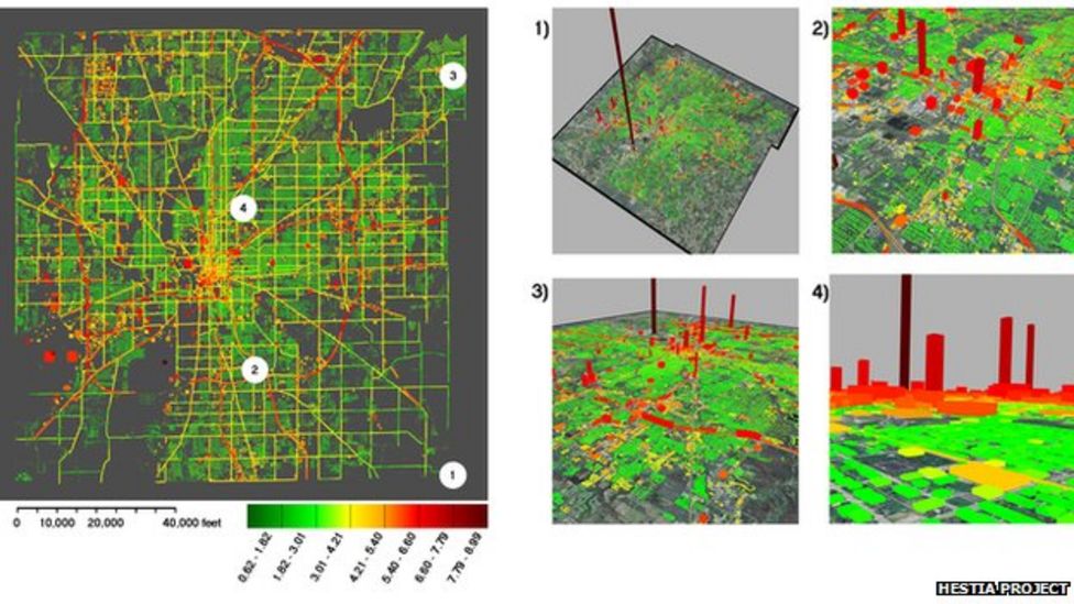
According to the scientists from Arizona State University this new measuring system, called Hestia, changes all that.
The research team used data from a number of sources including air pollution reports, traffic counts and tax offices. This is then combined with a modelling system for quantifying CO2 emissions down to individual building level.
Dr Kevin Gurney is one of the leaders of the project. He told BBC News that his team knows the system is working because it is consistent with existing information on emissions.
"We can go to any city in the US and do the quantification and we know it will be utterly consistent from city to city and consistent from city all the way up to national level," he said.
So far the system has been used on Indianapolis and work is ongoing with Los Angeles and Phoenix. The researchers are learning a great deal about emissions in the urban environment.
"You realise how large a source electricity production is. It tends to swamp the signal in cities. And things like traffic jams and slow downs in traffic, that's what really hits you," said Dr Gurney.
The scientists behind the system say it can be extremely useful for cities, helping them to target where to make emissions cuts.
Once those cuts have been made, the system can verify their effect. Verification is also a hugely contentious issue at international negotiations on a global climate treaty.
Many developed countries are concerned that any cuts in carbon agreed by developing nations might not actually happen. Could this system help? Kevin Gurney believes it would.
"Right now we are exploring the use of remote sensing but the nice thing is that now we can use Hestia to calibrate the remote sensing in the cities we have done. Through that we may be able to infer a lot better estimate of emissions in Rio or Delhi," he said.
The researchers believe that the system can be used to give greater credibility to carbon trading.
"Nobody buys a stock that's ten dollars plus or minus five dollars," said Kevin Gurney. "We have to have confidence in the numerical value of something. We have to have the same level of confidence about a unit of emissions."
- Published21 February 2006
- Published11 May 2011